About Chamber
Directions
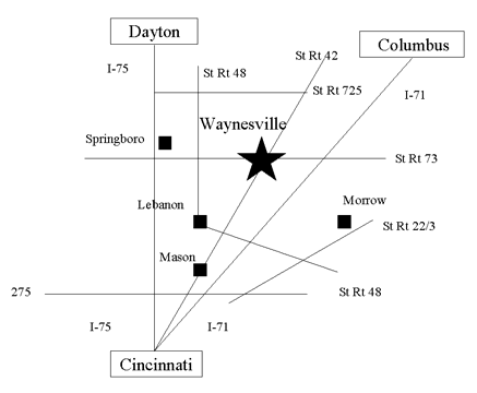
Directions
From Cincinnati:
Take I-71 north to Exit 45 (Waynesville), then 4 miles west on State Route 73.
-or-
Take I-75 north to Exit 38 (Springboro/Franklin), then 15 miles east on State Route 73.
From Dayton:
Take I-75 south to Exit 38 (Springboro/Franklin) then 15 miles east on State Route 73 or Rte 48 south
to St. Rte. 73, east on 73 for 5 miles.
From Columbus:
Take I-71 south to Exit 45 (Waynesville), then 4 miles west on State Route 73.
From Cleveland:
Take I-71 south about 1 hour south of Columbus to Exit 45 (Waynesville), then 4 miles west on State Route 73.
From Toledo:
Take I-75 south about 20 minutes south of Dayton to Exit 38 (Springboro/Franklin) then 15 miles east on State Route 73.
From Indianapolis:
Take I-70 east to Dayton, then take I-75 south to Exit 38 (Springboro/Franklin) then 15 miles east on State Route 73.
-or-
Take I-74 east to Cincinnati, then I-75 north to Exit 38 (Springboro/Franklin), then 15 miles east on State Route 73.
Driving Times
From I-90
Albany, NY 725 miles
Buffalo, NY 425 miles
From I-80
Chicago, IL 285 miles
Fort Wayne, IN 150 miles
New York, NY 570 miles
From I-70
Indianapolis, IN 120 miles
Philadelphia, PA 500 miles
Pittsburgh, PA 270 miles
From I-71
Cleveland, OH 200 miles
Columbus, OH 90 miles
Louisville, KY 120 miles
From I-75
Detroit, MI 210 miles
Lexington, KY 100 miles
Toledo, OH 190 miles
Toronto, ONT 450 miles
Windsor, ONT 240 miles
From US 50
Charleston, WV 230 miles